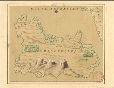
Chesepritri* off the coast of Candia, south of Tolo.
Mid-16th C, redrawn 18th C.
Mid-16th C, redrawn 18th C.
From the Bibliothèque Nationale, Paris, identified as Poros.
What Albanian word would the French have heard as Chesepritri?
In January I wrote an entry about how the number 6000 became the definitive number whenever the troop strength of the Morea was estimated. This works very well, if you take some simplistic calculations. Sphrantzes said that there were 30,000 Albanians. Assume half were males, 15,000. Evidence from various population groups in medieval and pre-modern Greece suggests that from 37-54% were under the age of 14, or 5550-8100. That is a very wide range, from 9850 down to 6900 adult males, and if you consider the ones too old or too injured to fight, or those needed to keep an eye on the settlements and herds, 6000 is quite reasonable.
There is one other estimate of stratioti numbers in the Morea to consider.
Chesepritri is the green island, farther down the coast than this suggests.
The blue is Ropolı/Romvi, the red Daskalo in the bay off Tolo.
Nauplion upside-down. Piri Re'is, 1574 edition of 1520s map.
Piri Re'is's islands should be rotated 90 degrees clockwise.
Piri Re'is's islands should be rotated 90 degrees clockwise.
In 1465, Jacopo Barbarigo (in charge of Venetian forces in the Venetian-Ottoman war in the Morea) said that the territories of Methoni and Koroni could only support about 150 horses each -- he was having a difficult time getting feed for the stratioti's horses, and many had starved to death. Although he was stationed in upper Mani, he had to keep most of his forces up in Nauplion territory.
He said he had a total of 1500 stratioti, in addition to the Italian troops. He estimated that there were between 2000 and 3000 stratioti fighting with the Ottoman troops. This would be a total count of 3500-4500 stratioti in the Morea. What happened to the other 1500-2500?
He said he had a total of 1500 stratioti, in addition to the Italian troops. He estimated that there were between 2000 and 3000 stratioti fighting with the Ottoman troops. This would be a total count of 3500-4500 stratioti in the Morea. What happened to the other 1500-2500?
Στὸ βουνὸ would be my guess, assuming there had been about 6000 earlier. The Ottomans are only recorded as having one battle in the field with stratioti, and that was in 1423. Barbarigo gives accounts of one side coming upon the other en route, or an occasional ambush, but all other accounts concern sieges and raiding the countryside. Stratioti, with horses, did not think much of sieges, from either side.
Chesepritri more accurately located by GoogleMaps,
triangular plain of Canda right, Nauplion upper left.
triangular plain of Canda right, Nauplion upper left.
In the Nauplion area, the stratioti had been given the land at Aria and Candia, in the flat triangular plain south-east of the coastal mountains and the narrow road past the bay of Drepanon. (The area produces artichokes today.) In theory, and following the Byzantine system, stratioti had land on which to support themselves and their families, and otherwise they were paid in loot. In practice, as Minio found in the summer of 1480, stratioti could not collect their harvest and then pay their harvest taxes, if they had to be armed and on full alert for an Ottoman attack just at harvest time. Or, as Barbarigo kept trying to explain to Venice, stratioti could not feed themselves if they had been away from home for three years and were always on the move. (For more on stratioti pay, here.)
This gets us to Chesepritri, the large island in the bay between Tolo and Candia. The French map emphasizes pastures which are difficult to have confidence in looking at the aerial map of the island. I do not know how many farm plots and how many horses the plain of Candia could maintain. This site on horses suggests 1 1/2 acres of good pasture land -- 6 stremmata -- dung-free, per horse. So I suspect that Chesepritri's pastures provided a home for some of the stratioti's horses, probably the mares and foals, as the others would at times be needed immediately.
Chesepritri itself, showing that the 16th-C map was not too far off.
Modern houses in just about the same locations, some pasture areas.
* Thanks for the Chesepritri map to Pavlos Plessas, himself from a stratioti family known at the time the original map was made, the Blessi.


Dear Diana,
ReplyDeleteRegarding the name of the island on the name and what may its meaning be . . . 'chesepitri'
I asked a very good friend who is from a village of arvanites named 'Malessina' and where you can still find quite some fluent speakers of 'arvanitika' such as his father.
Well this is the maximum the deciphering that we made:
Ο πατερας μου δεν ξερει τετοια λεξη.
Παντως 'Κεσε' σημαινει γελαω :)
κ 'τσεσε' σημαινει στηθος
κ 'πριτεμ' σημαινει κομμενος
το οποιο ειναι το κοντινοτερο στο 'πριτρι' που σκεφτηκε.
Whatabout 'a cut breast' :-)
Best regards
Oh, dear . . . I hope that's not it.
ReplyDeleteStill, that is interesting, because the nearest island has a local name of "the tits of Aphroditi" and you can see them on the blue island in the second map above.
That would be "i stithi tis Aphroditis."
ReplyDelete